Drone Photogrammetry: A Revolution in 3D Model Creation
Drone photogrammetry has burst onto the scene in geospatial technology as an innovative tool that significantly improves the accuracy and efficiency of creating maps and 3D models.
With the ability to capture detailed aerial images, this technique optimizes both time and costs in a variety of applications, from surveying to civil engineering. In this post, we’ll tell you how drone photogrammetry is reshaping—and revolutionizing—the landscape of geospatial data collection.
What is drone photogrammetry?
Photogrammetry is a method for obtaining precise information about objects and spaces through the analysis of photographs. Traditionally, this technique was performed using small planes or satellites, but for just over a decade now, drones have offered a faster, cheaper, and safer alternative.
Drone photogrammetry involves using these unmanned aircraft to capture multiple aerial images that, when processed with specialized software, allow the creation of high-resolution 2D or 3D models.
Types of Photogrammetry
There are several types of photogrammetry, each suitable for different applications:
– Aerial photogrammetry: This is the main topic of this post. It uses drones to capture aerial images, ideal for mapping and terrain modeling.
– Terrestrial photogrammetry: Involves capturing images from the ground, used mainly in architecture and archaeology.
Benefits of aerial photogrammetry
The use of drones in photogrammetry presents several significant benefits:
– Cost reduction: While drones were not a cheap solution at all a few years ago, the democratization of these aerial devices has made them the most economical option for capturing aerial images today.
– Improved accuracy: The ability to capture detailed images allows for highly accurate maps and models.
– Time efficiency: Drones can cover large areas in a short time, speeding up the data collection process.
– Safety: Drone photogrammetry minimizes the need for field personnel, reducing the risks associated with fieldwork.
How is photogrammetry done with drones?
To perform photogrammetry with drones, there are several key steps to follow:
1. Flight planning: The flight must be planned considering the area to be covered, the altitude, and the weather conditions.
2. Image capture: The drone, equipped with a high-resolution camera, captures multiple images of the desired area.
3. Data processing: The captured images are processed with drone photogrammetry software such as 2fVideomodeling to generate 3D models.
4. Data analysis and use: The generated models are used for various applications, from cartography to civil engineering.
Practical uses of drone photogrammetry
Drone photogrammetry has applications in multiple fields, including:
– Topography: To create precise geographic plans and maps.
– Precision agriculture: Monitor crops and optimize resource management.
– Civil engineering: Planning and monitoring of construction projects.
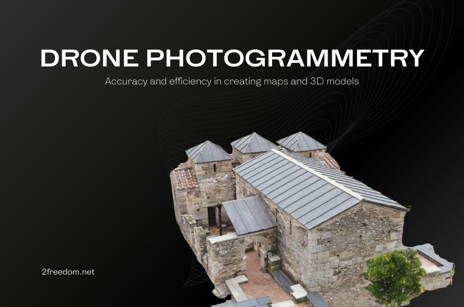
– Archaeology: Document and analyze archaeological sites for 3D digitization of heritage.
– Mining: Evaluate and manage mining resources.
Necessary equipment and software
To perform drone photogrammetry effectively, it is essential to have the right equipment and software:
– Properly equipped drone: It is essential to have a drone equipped with high-resolution cameras and accurate GPS.
– Specialized software: Tools such as 2fVideomodeling to process images and generate accurate models.
– Technical knowledge: Training in flight planning and operation of image processing software.
Conclusion
Drone photogrammetry represents a revolution in geospatial data collection, offering a faster, more economical, and more accurate alternative to traditional methods. With a wide range of applications, from surveying to civil engineering, aerial photogrammetry continues to expand its horizons, transforming the way we interact with our environment.
For a better visual understanding of how drone photogrammetry works, we recommend watching the following video:
Technology is advancing rapidly, and drone photogrammetry is at the forefront of this transformation, offering powerful tools to capture and analyze the world around us with unprecedented precision.